SDN Team
Author - SDN Team

After almost a century, and several failed attempts to establish a coherent rural land identification and registration system across the whole of Portugal; a cooperative initiative between different Government sectors was created in 2017. This initiative had one goal: to finally understand who owns what, and where.

Service Design Award 2019 Finalist Project

Designing a viable land for future generations - by With Company

Category: Professional Commercial

Client: Government / Ministry

Location: Portugal

Introduction

After almost a century, and several failed attempts to establish a coherent rural land identification and registration system across the whole of Portugal; a cooperative initiative between different Government sectors was created in 2017. This initiative had one goal: to finally understand who owns what, and where.

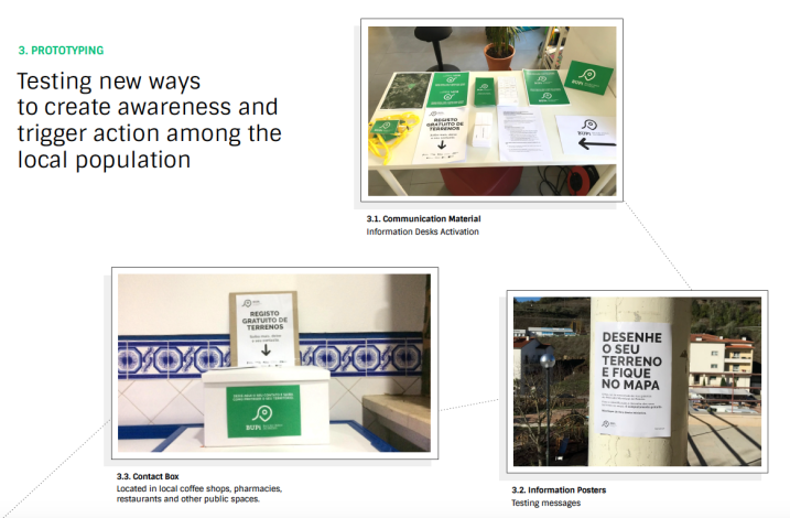
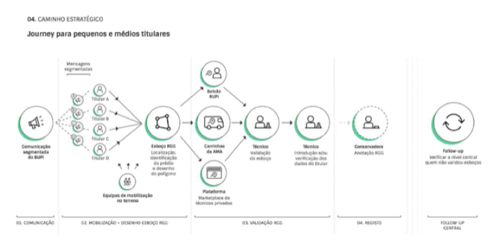
In order to test a new approach, a pilot-project targeting 10 municipalities in the interior region of Portugal was created. Its goal was to mobilize rural property owners to identify the location and limits of their properties on a digital map, based on satellite images , at local information desks and with the help of specialized technicians. Our role was to design the entire experience of this public service and define the mobilization strategy, with the goal of mapping more than 50% of the combined territory across these 10 locations.
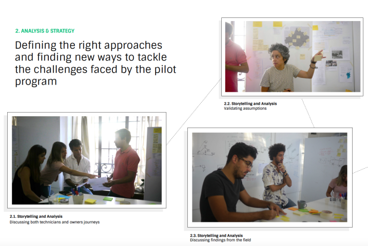
Process

Through a Service Design approach, we immersed ourselves in this context by re-locating ourselves to one of the municipalities, listening carefully, exploring the lands, engaging stakeholders and putting the users and client at the centre of the project. We set up a dedicated team of distinctive brains (Researcher, Creative Strategist, Strategist, Digital
Designer and a Multidisciplinary Designer) and engaged the remaining project partners to create the conditions to generate good ideas and outcomes.
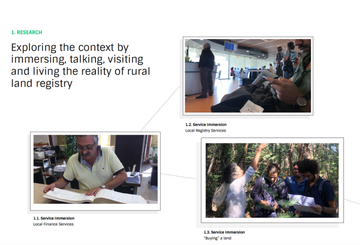
Research

We used qualitative and ethnographic research methods as a way to explore the problem from different perspectives. We did in-depth interviews, to learn about the origins, the stories and the relationships people have with their lands. We made participatory and non-participatory observations, to see how people actually manage and define the limits of their lands and also learn about how they experienced the service. We did context immersion , by putting ourselves into a land identification and registry process, where we even tried to buy an 11,572m 2 property. We used mobile ethnography, to self-document the experience. We facilitated co-creation sessions, to involve and generate commitment from local stakeholders and ultimately, we role-played and prototyped for empathy, to learn and test different scenarios, experiences and approaches to the population.

During our research we conducted over 40 interviews, observed more than 30 processes from users at the information desks, involved more than 15 local stakeholders in participatory design sessions, visited more than 14 locations (10 municipalities + other similar contexts), travelled more than 5,000 km and by doing this we were able to:

  • Explore and find out how people protect their properties and the meaning of protection;
  • Learn more about the differences between owning a piece of land and belonging to a land;
  • Understand the motivations and barriers of landowners to identify their properties;
  • Identify different landowners profiles (big property owners, small and medium property owners and future inheritances);
  • Identify local mobilizers and community influencers (priests, investors, local business owners, presidents of associations, volunteers, fireman & police officers, among others);
  • Identify key places to inform and interact with the population (main cafes, markets, associations and public areas);
  • Identify needs and opportunities to improve the current service experience (online platform, information desks, communication and other touchpoints);
  • Test different approaches to the populations (communication, land identification, mobilization actions);
  • Identify a new direction to the scaling of the service and project (big-data concept model);

Main Insights

Throughout the research we aimed to continuously document (audio recordings, videos, photos and interviews scripts), analyse and interpret the information we were gathering. Among dozens of findings, we were able to identify key insights such as:

  1. When thinking about protecting their properties, landowners are more motivated and concerned when they feel that someone can appropriate or wrongly identify the limits of their properties, because no one wants to lose what’s theirs.
    Pairing this with the fact that the "declared area" was much larger than the physical area of the territory, we came to realise that there was a significant amount of overlapping. Understanding that this wasn't desirable for these landowners, we translated this into a key message for the mobilization strategy.
  2. When identifying the limits of their properties at the information desks, landowners and technicians lost a lot of time just to find the location of a property on the map, being the time of technicians more valuable just in the technical
    validation of the final georeference.

    When crossing this with the increasing waiting list of landowners at the information desks, it highlighted the need to decentralize these information desks and split the process into two separate stages: identification and validation. A new journey and experience had to be designed.
  3. From the beginning of the program, we were anticipating a small margin of error; with landowners using satellite images to georeference their property, we expected some mistakes. Dependency on humans for the generation of knowledge was starting to become a major barrier to the timeline of the project.

    Based on this presumed margin of error, error and in an attempt to bypass this bottleneck, we proposed a new approach based on statistical prediction.

Prototyping and testing

Taking into account this and other insights, we were able to prototype and test several solutions and approaches along the way. Through ideation and co-creation we developed:

  • Communication materials & actions
    We developed different solutions (flyers, posters and local media) and participated in local street markets and initiatives to inform the population, and as a way of testing different messages/approaches and measuring
    conversion rates.
  • Information desks decentralization
    With the support of local municipalities, we were able to identify key locations and plan an itinerary route, to test how to bring the information desks closer to the population.
  • Indirect method
    We design the concept for an algorithm that could deduct the location and shape of a property with satellite images and historical text data about each property as an input. Together with the big data partner of the project, we developed this algorithm and did a proof of concept that ended up validating the ability to predict the location of any given rural property. The deduction of a property’s boundaries is the next step forward.

Outcomes

We produced several deliverables during the project, from recommendation reports, that were used to redesign the information desks; to communication assets, that were deployed from day one. We have divided the highlights into four main categories:

  1. Service Design report
    The main outputs of the service design report were: a redesign of the UX for the online platform; a redesign of the information desk experience; stakeholders mapping and suggested roles/responsibilities; persona building around the three types of owners we encountered; three different user journeys for each type of owner and based on the support each one needs; a strategy for the decentralisation of the service counters and technicians; and, a complete scaling strategy for a future national release. From this report, mobile information desks were deployed (vans), changes were made to the information desks, and both the project landing page and platform were modified.
    Other recommendations such as the creation of places were owners could use Google Earth to draw a draft, were tested across the municipalities.
  2. Communication strategy
    We delivered a second report focused only on communication. This included the identification of key messages to be used according to the different types of owners and their motivations, an umbrella concept, recommendations for both offline and online touchpoints, identification of key local stakeholders and how each should communicate, identification and mapping of local events, to be used for mass communication, and an 8 month tactical plan for the deployment of everything we proposed. We also delivered a national communication strategy that included a new version of the umbrella concept and a script for both TV and radio ads, with specific local adaptations.

    Though the national communication strategy can only be deployed with the national release of the program, some of the recommendations from the first report were implemented by the municipalities, although never at full scale.
  3. Communication assets
    Throughout the project, we delivered different communication assets. Before research, we designed the pilot program landing page and also created all the initial flyers and posters to be used by each municipality to inform the population. During our research, we prototyped new flyers and posters with different messages, that were then distributed in the places where the populations gathered (e.g. Wednesday's farmers market). We created new types of assets, like a Contacts Box that was used for both communication and collecting phone numbers from around the municipality we were based in. After delivering the reports, we also created a new umbrella brand for the pilot program, an institutional video that explained how the pilot worked and a new mood for both posters and flyers.
  4. Indirect method report
    After the algorithm passed the proof-of-concept, we outlined ways to integrate it with the existing information desks and platform flow. The output, already implemented, is a feature that uses a property number and a single click to suggest to a property owner the area where its property is most likely to be located. This feature allows for a significant
    decrease in the time both owners and technicians need to navigate the satellite images.

    Out of this proof of concept also came a proposal for a new national system that centralizes dispersed public information in order to extract knowledge about the territory. This proposal is still awaiting approval.

Main impact

Our work impacted the pilot program in two main ways. First, by significantly improving the existing process. And secondly, by bringing to the table a new way of approaching the challenge, one that didn’t rely on a slow information gathering process.

This impact can be easily measured over time. Before the program was launched, there were 243,195 hectares of properties that needed to be georeferenced by their owners across the 10 pilot municipalities. From November 2017 to the middle of January 2018, the program achieved a 2% registration and identification rate. This was around the time when we presented our research reports and the new, indirect, approach.

Once the service design report recommendations started being applied, we saw significant improvements in the number of properties georeferenced across all municipalities, and the percentage of registration and identification skyrocketed to more than 50%, as of November 2018.

This percentage represents 112,067 hectares of rural land properly identified and labelled, with a significant percentage coming from 82,860 contributions made by citizens. On top of this, the mobilization strategy brought 45,000 individual counter bookings that couldn’t be fulfilled as of November, thus by the end of the project, demand exceeded supply.

On the other hand, although not yet law-abiding, the indirect method allowed us to identify the location of all existing rural properties belonging to citizens across the 10 municipalities.

Through this method, we were also able to centralize the geolocation data about public properties, forests and agricultural land that was until now dispersed and thus not taken into account for land management policies. During the project, this type of properties accounted for 112,067 hectares of georeferenced land.

On a more qualitative dimension, our participatory research approach, that took us to one of the municipalities for a month, had a direct impact on the involvement of all local players and the willingness of the local population to be part of the pilot program.

In the end, these results made the pilot program a success, and a timeline extension was granted so that the missing area can also be georeferenced throughout 2019. The expansion of the program to the entire Portuguese territory is now being discussed and should be rolled out by the end of 2019.

Final conclusion

This project was the perfect fit between a complex problem, political will, a wide range of public and private partners, motivated teams and a design approach for problem-solving. Throughout it, we had to demystify myths about what it means to manage rural land, the best methods for property identification, how owners value their properties, the role of municipalities and much more.

We also had to collaborate with many entities that had never before heard about service design or design thinking. But through continuous positive results, we were able to build trust.

We went from analysing 50-year-old documents by hand, to deploying big data and machine learning across huge sets of data. Along the way, we had to question the service design tools, methods and processes we have always used, and re-created them, so they would allow for deeper participation, beyond listening and observation.

The approach we deployed is seen inside the Government as ‘The Way’ to tackle challenging problems, with the broader discipline of design being now seen as capable of leading these kinds of projects.

As of today, we are already working on a bigger challenge: how to transform this pilot program into just one use case of a thousand ones that could be solved through a platform, open to all, that centralizes public-data related to rural land?

Related Community Knowledge

Service Design Award Transforming the US Health System: A toolkit for designing a new era of Alzheimer’s care

Transforming the US Health System: A toolkit for designing a new era of Alzheimer’s care

Service Design Award 2023 - Professional Commercial Finalist

Continue reading
Service Design Award Nemo: The Finnish Maritime Single Window

Nemo: The Finnish Maritime Single Window

Service Design Award 2023 - Winner, Best Commercial Project

Continue reading
Service Design Award Inspiring Action for Teacher Retention from the Inside Out

Inspiring Action for Teacher Retention from the Inside Out

Service Design Award 2023 - Professional Commercial Finalist

Continue reading
Service Design Award Fast Stream: A new post-pandemic digital service

Fast Stream: A new post-pandemic digital service

Service Design Award 2023 - Professional Commercial Finalist

Continue reading